
Page 6 - Microsoft Word - DIGITAL ATLAS THOOT-1
P. 6
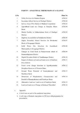
PART IV – ANALYTICAL THEME MAPS AT A GLANCE


                        S.No                            Themes                               Plate No
                          1      Utility Services for Madurai Region                         ATM.01

                          2      Secondary School Service in Dindigul District               ATM.02
                          3      Service Area of Fire Station in Madurai Corporation         ATM.03

                          4      Agricultural Land use Change in Manjalar Minor              ATM.04
                                 Basin

                          5      Market Facility in Oddanchatram block of Dindigul           ATM.05

                                 District.
                          6      Highway Accessibility in Pudukkottai District               ATM.06

                          7      Higher Secondary School Services for Devakottai             ATM.07

                                 Block of Sivagangai District
                          8      Solid   Waste    Site   Selection   for   Karaikkudi        ATM.08

                                 Municipality in Sivagangai District.
                          9      Changes in Coral Reefs in Rameswaram island of              ATM.09

                                 Ramanathapuram District
                         10      Digital Elevation Model of Virudhunagar District            ATM.10

                         11      Impact of climate on Land use/Land cover of Southern        ATM.11

                                 three districts
                         12      Forest cover change detection in Agasthiyarmalai            ATM.12

                                 Biosphere Reserves of Western Ghats.
                         13      Ground Water Potential of Kanniyakumari and                 ATM.13

                                 Nambiyar Basin
                         14      Dimension of Morphometric Characteristics and               ATM.14

                                 Rainfall of Kanniyakumari and Nambiyar Basin

                         15      Alternative Land use/ Land cover of Nambiyar Basin          ATM.15
                         16      Land use/Land cover Change in Kodayar Watershed             ATM.16


                       v.     Appendix

                          a.  A brief note on each of the analytical map plates

                          b.  A soft copy of thematic map plates in CD form with programme for
                              presentation